As industries and governments strive to make smarter, data-driven decisions, the need for precise, real-time analysis has never been greater. In fact, by 2026, the geospatial analytics AI market is projected to reach a staggering $172 million.
In this article, we’ll explore the most impactful use cases for GeoAI that are driving innovation in 2025. We’ll also review key APIs and platforms to help you begin leveraging geospatial intelligence in your own projects or new product development work.
- Geospatial artificial intelligence basics
- 12 geospatial AI use cases driving innovation in 2025
- 1. Real estate market trend analysis
- 2. Customer intelligence
- 3. Public health analysis
- 4. Logistics route planning
- 5. Agriculture crop yield optimization
- 6. Finding mineral deposits
- 7. Renewable energy potential mapping
- 8. Sustainable city planning
- 9. Fire risk assessment
- 10. Water resource management
- 11. Wildlife habitat conservation
- 12. Tree canopy mapping
- Geospatial APIs and datasets
- SoftKraft’s AI development services
- Conclusion
Geospatial artificial intelligence basics
GeoAI, or Geospatial Artificial Intelligence, combines geographic data with machine learning to analyze and visualize spatial patterns and trends, offering advanced insights into various applications. This technology is completely revolutionizing the way businesses analyze and leverage spatial data and opening up a vast array of new use cases across industries.
At a high-level, GeoAI offers three key benefits:
- Improved data quality: GeoAI enhances data consistency and accuracy by automating data generation, significantly reducing manual errors and ensuring higher reliability of spatial data.
- Increased efficiency: By automating workflows, GeoAI streamlines operations and boosts productivity by enabling organizations to analyze geospatial data more effectively, reducing operational costs and allowing them to focus on more strategic tasks.
- Enhanced decision-making: Geospatial AI leverages location intelligence to provide actionable insights, enabling data-driven decisions with a clear understanding of spatial patterns, ultimately improving business outcomes through precise predictions and informed strategies.
12 geospatial AI use cases driving innovation in 2025
As Geospatial AI continues to gain momentum, its applications are expanding across various industries, driving significant innovation. In this section, we will explore the top 12 use cases for GeoAI that are set to lead the way in 2025.
Real estate market trend analysis
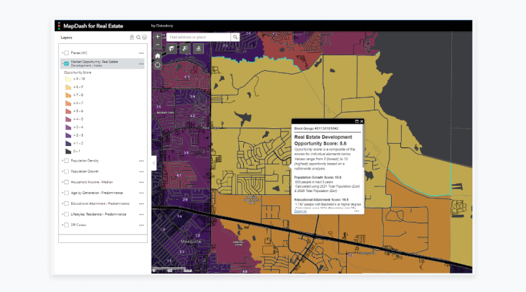
Geospatial intelligence provides advanced tools to analyze market trends and make strategic decisions. GeoAI combines geographic data with machine learning to offer insights that help real estate professionals understand and anticipate market dynamics. Here’s how GeoAI can benefit the real estate sector:
- Mapping and visualization: Geospatial analysis enables the detailed mapping of properties via spatial analysis, showcasing their locations in relation to key geographic and urban features such as amenities, infrastructure, natural landscapes, and significant landmarks.
- Location analysis: Advanced analytics is possible on an unprecedented scale, with an evaluation of the influence of a property's location on its value, taking into account factors like neighborhood characteristics, school districts, crime rates, access to public transportation, and proximity to commercial or recreational amenities.
- Market trends and demographics: Geospatial tools analyze demographic shifts, housing trends, and economic developments across different areas, aiding in the understanding of potential property demand in various neighborhoods.
- Risk assessment: GeoAI assesses environmental risks via geographical data, including flood zones, earthquake fault lines, and wildfire areas, along with other location-based risks of natural disasters that can impact property values and insurance costs.
Read More:
10 Real Estate AI Use Cases Transforming the Industry in 2025
10 Proven Real Estate APIs That Deliver Unrivaled Market Insights
Customer intelligence
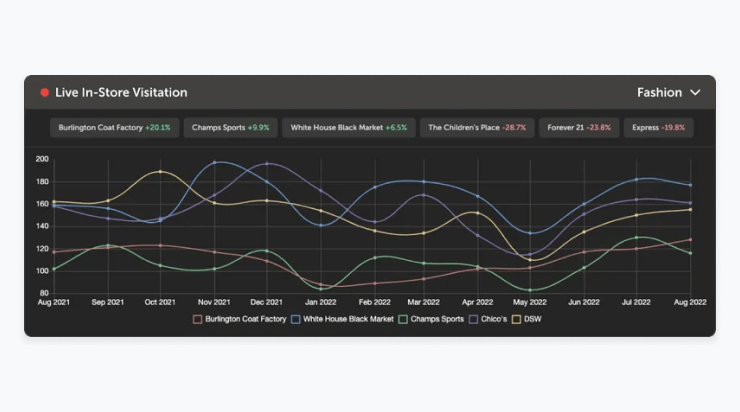
GeoAI is enhancing customer intelligence by providing businesses with detailed insights into consumer behavior and preferences based on spatial data. Companies like Spatial.ai leverage GeoAI to analyze location-based data, offering valuable insights into customer dynamics and enabling more targeted marketing strategies.
By integrating geospatial data with AI, businesses can identify trends and patterns in customer behavior, such as where they shop, dine, and spend leisure time. This analysis helps in segmenting markets more precisely and tailoring marketing efforts to highly-specific geographic areas. Additionally, through deep learning, GeoAI can predict future customer behavior based on historical data, allowing businesses to anticipate needs and adjust their strategies accordingly.
Read More: Top 6 AI Marketing Tools That Changed Digital Marketing Forever
Public health analysis
GeoAI offers transformative potential in healthcare by facilitating real-time analysis for the swift identification of emerging health trends and timely interventions. This technology utilizes geospatial data and maps to analyze patterns and trends within a geographic context, mapping environmental elements associated with disease disparities and providing evidence-based support for diagnosis and treatment.
By integrating diverse data types, including demographic, environmental, and healthcare information, GeoAI helps understand the complex factors contributing to disease disparities. This enables public health professionals to make informed decisions, improve resource allocation, and enhance healthcare outcomes efficiently.

Logistics route planning
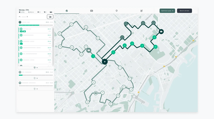
Geospatial AI is transforming logistics route planning by providing real-time traffic pattern analysis and optimizing delivery routes. By leveraging geographic information systems (i.e. GIS data) and combining it with AI, logistics companies can navigate traffic complexities more effectively, identify congestion hotspots, consider factors like road closures and weather, enabling dynamic adjustments to delivery routes.
This can not only enhance operational efficiency but also reduce fuel consumption and vehicle wear and tear, leading to significant cost savings and lower emissions.
Agriculture crop yield optimization
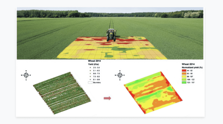
GeoAI helps in monitoring crop health, predicting yields, and managing resources more efficiently. Unlike traditional data analysis, GeoAI integrates and analyzes vast amounts of diverse data sources in real-time, providing unprecedented precision and actionable insights that were previously unattainable.
Here are some specific ways GeoAI is optimizing crop yields:
- Variable rate application (VRA): AI generates prescription maps that guide farm machinery to apply fertilizers or pesticides at precise rates tailored for different field areas, optimizing resource use and minimizing waste.
- Disease and pest detection: AI-powered image analysis detects early signs of disease and pest infestations, enabling targeted and reduced pesticide application, thus promoting healthier crops and reducing chemical use.
- Soil moisture mapping: AI combines satellite imagery with sensor data to identify areas needing irrigation, ensuring efficient water usage and maintaining optimal soil moisture levels for crop growth.
- Yield prediction: AI models forecast crop yields, aiding in harvest planning, logistics optimization, and informed market decisions, ultimately enhancing profitability and sustainability.
- Data-driven optimization: AI analyzes historical and real-time data to continuously refine farming practices, resulting in higher yields and improved agricultural efficiency over time.
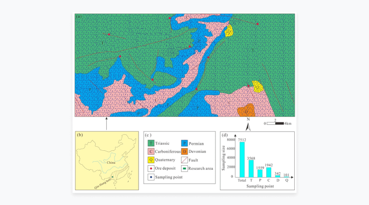
Finding mineral deposits
Traditionally, locating mineral deposits has been a time-consuming and costly process involving extensive field surveys, drilling, and geological mapping. However, GeoAI is revolutionizing this approach by providing sophisticated tools to identify mineral-rich areas with greater accuracy and efficiency. By analyzing vast amounts of geological data, satellite imagery, and environmental factors in real-time, GeoAI pinpoints promising sites that were previously difficult to detect.
This advanced method not only reduces the time and cost associated with traditional prospecting but also enhances resource discovery and minimizes environmental impact. With GeoAI, mining companies can make more informed decisions, optimize exploration efforts, and increase the likelihood of successful mineral extraction.
Renewable energy potential mapping
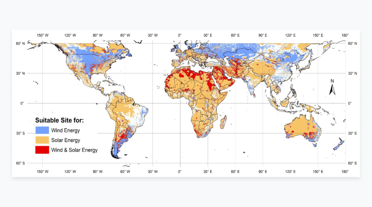
Geospatial AI is revolutionizing the identification of renewable energy generation sites by analyzing critical geospatial data such as solar radiation, wind speeds, and land suitability. This advanced technology allows for precise mapping and assessment of areas with the highest potential for solar and wind energy, enabling more effective planning and implementation of renewable energy projects. This entails:
- Solar radiation analysis: Geospatial AI can process data to identify locations with the highest solar radiation, ideal for solar power installations.
- Wind speed evaluation: GeoAI pinpoints areas with consistent, strong wind speeds suitable for wind turbines.
- Land suitability assessment: GeoAI evaluates factors such as topography, land use, and proximity to infrastructure to ensure renewable energy projects are efficient and feasible.
Sustainable city planning
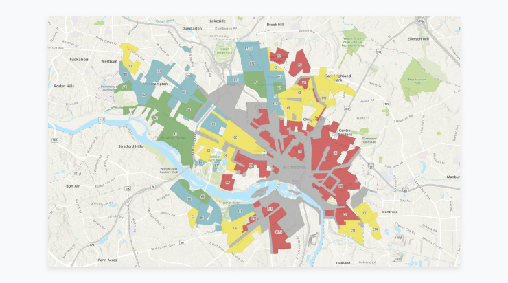
Geospatial AI plays a crucial role in sustainable city planning, enabling urban planners and policymakers to create more efficient, livable, and environmentally friendly cities. Here are three key use cases of GeoAI in sustainable city planning:
- Modeling impacts of urban development: Geospatial AI allows urban planners to predict changes in land use and assess ecological impacts, ensuring sustainable infrastructure development and compliance with environmental regulations.
- Urban heat island monitoring: By using satellite imagery and temperature data, Geospatial AI creates heat maps to identify urban hotspots, helping planners introduce green spaces to cool down these areas and improve livability.
- Traffic congestion analysis: GIS analysis and AI aid in real-time traffic data to identify congestion hotspots and optimize public transportation routes, reducing reliance on private vehicles and lowering emissions.
Fire risk assessment
Geospatial AI introduces unprecedented precision and intelligence in fire risk assessment, revolutionizing disaster response by enhancing the prediction, monitoring, and management of fire hazards. By integrating diverse geospatial data sources—such as high-resolution satellite imagery, vegetation density, weather patterns, and topographic data—with advanced AI techniques, GeoAI delivers highly accurate and actionable insights.
This technology enables real-time monitoring of changes in vegetation and environmental conditions, providing early warnings of potential fire outbreaks. The precision of GeoAI allows for the detection of subtle indicators, such as dry vegetation and wind patterns, that traditional methods might overlook, significantly improving disaster response efforts.

Water resource management
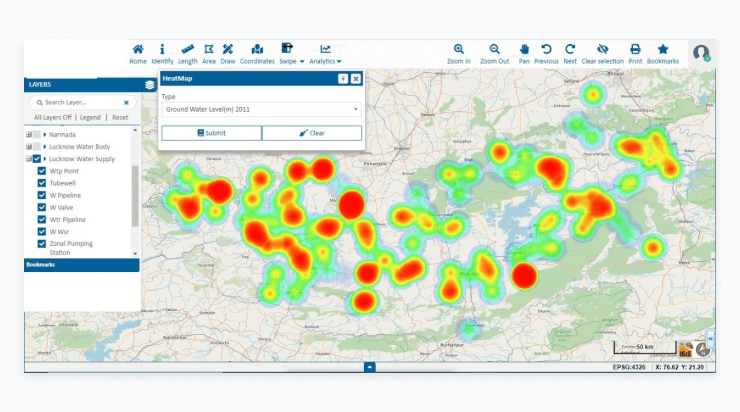
Geospatial AI is transforming water resource management by providing precise tools to analyze and optimize water use. By integrating data such as rainfall patterns, groundwater levels, river flow, and soil moisture, GeoAI enables more informed and efficient resource management. Leveraging deep learning techniques, GeoAI offers advanced insights and solutions for sustainable water management. Key benefits include:
- Real-time monitoring: Tracks current water conditions to predict future scenarios, ensuring sustainable use and proactive management.
- Detailed mapping: Identifies areas of water scarcity and abundance, helping to balance supply and demand effectively.
- Flood risk assessment: Analyzes river flow data to offer early warnings and proactive measures, mitigating flood risks.
Wildlife habitat conservation
GeoAI can detect subtle changes in land use and environmental conditions, providing early warnings of potential threats to wildlife. This advanced technology facilitates the identification of critical habitats, tracks habitat degradation, and assesses the impact of human activities on biodiversity. By leveraging high-resolution satellite imagery and real-time data analysis, GeoAI allows conservationists to implement targeted interventions and conservation strategies with unprecedented accuracy.
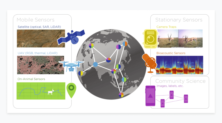
Moreover, GeoAI can automate tasks such as monitoring environmental changes and identifying patterns that may signify emerging threats. This not only improves efficiency but also enhances the effectiveness of environmental protection efforts. By providing detailed insights and early warnings, GeoAI empowers conservationists to make data-driven decisions that support sustainable wildlife management and biodiversity preservation.
Tree canopy mapping
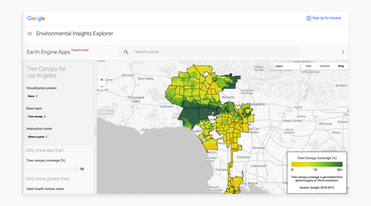
The rapid advancements in artificial intelligence and foundational models are transforming how we interact with our environment. In recent years, forest mapping through remote sensing has seen significant improvements in scale, resolution, and refresh rate. With 1-meter sensitivity, it is now possible to detect even small changes in canopy height.
While deforestation monitoring often relies on lower-resolution imagery due to the large areas affected, the enhanced capabilities of GeoAI allow for more precise and timely observations. This progress is supported by the availability of geospatial APIs and datasets, facilitating better environmental management and conservation efforts.
Geospatial APIs and datasets
Harnessing the power of Geospatial AI requires access to various APIs and datasets that provide the necessary spatial data for analysis. In this section we highlight some key geospatial APIs to consider:
- IBM Environmental Intelligence Suite: A SaaS platform designed to monitor, predict, and respond to weather and climate impact. It helps companies proactively manage risk, build sustainable operations, and assess how extreme weather events impact their business operations.
- Environmental Systems Research Institute: A leading American multinational geographic information system (GIS) software company. Their flagship product, ArcGIS, provides powerful GIS capabilities for understanding and analyzing spatial data for urban planning, infrastructure management, and environmental industries.
- Spatial.ai: Leverages unstructured social media data to provide richer consumer insights. Their geospatial object detection and recognition APIs analyze satellite imagery, street photographs, and video frames.
- Skydnn Geospatial: Offers state-of-the-art AI that processes satellite imagery and street photographs, returning JSON responses with confidence scores, labels, and geometry for uses in land segmentation, water bodies identification, and vegetation analysis.
SoftKraft’s AI development services
If you're looking for a partner to help develop and implement a custom geospatial AI solution, we’d love to help! Our team offers a wide range of custom AI development services and will work with you to build a comprehensive AI strategy. We'll help you select the most suitable GeoAI platforms or APIs, seamlessly integrate them into your existing tech stack, and deliver a business-aligned GeoAI system that meets your business needs.
Conclusion
GeoAI is driving innovation across various sectors by providing advanced tools for analyzing and leveraging spatial data. As we move into 2025, the diverse applications of GeoAI, from real estate market analysis to environmental protection, highlight its transformative potential. By embracing GeoAI, businesses and governments can make smarter, data-driven decisions that enhance efficiency, sustainability, and strategic planning.





![What is PropTech? 2025 Guide [+15 Fastest-Growing Startups]](/uploads/blog/what-is-proptech/what-is-proptech.png)
![Top 7 Smart Building Software Solutions [2025 Review]](/uploads/blog/smart-building-software/smart-building-software.png)